How Airspace Classes Are Drawn on a Sectional Chart
Cómo se dibujan las clases de espacio aéreo en una carta seccional
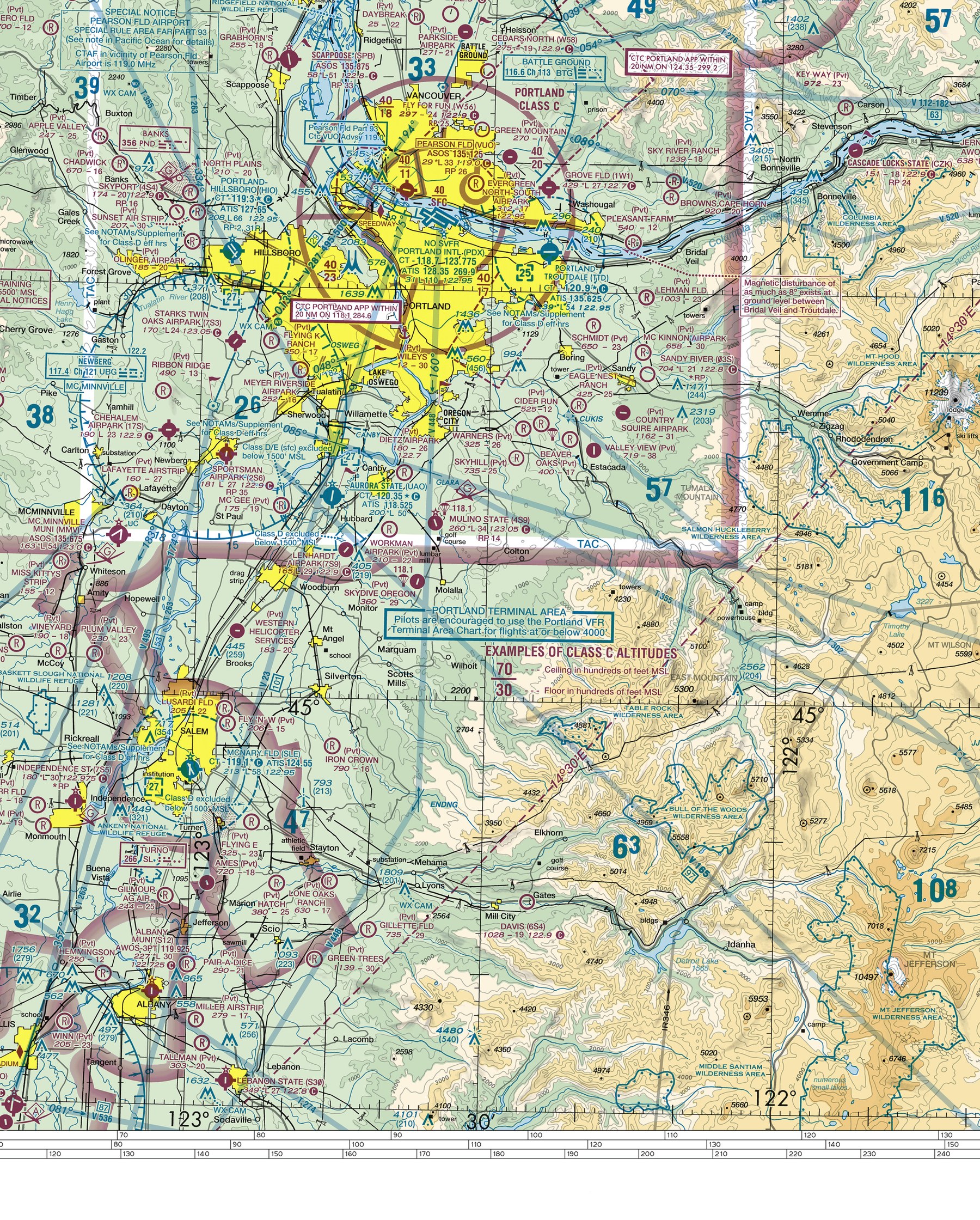
Real airspace boundary symbols on the Seattle sectional chart — tap one to identify it.
Símbolos reales de límites de espacio aéreo en la carta seccional de Seattle — toca uno para identificarlo.
Match each controlled airspace class's real chart depiction (line style, color, and altitude notation) to the correct class, building directly on the Airspace domain's classification knowledge.
Knowing the six airspace classes conceptually only becomes useful in the cockpit once a pilot can actually recognize each one on the real chart in front of them — this lesson connects that conceptual knowledge to the exact lines and colors a pilot will actually see.
Teach It / Enséñalo
ENTIENDE
Cada clase de espacio aéreo controlado usa un estilo de línea y color específico y consistente en las cartas seccionales. El espacio aéreo CLASE B se delinea con una línea AZUL SÓLIDA. El espacio aéreo CLASE C se delinea con una línea MAGENTA SÓLIDA. El espacio aéreo CLASE D se delinea con una línea AZUL DISCONTINUA (segmentada). Para los tres, los límites de altitud se imprimen directamente en la carta cerca del límite. El espacio aéreo CLASE E usa un enfoque visual diferente: una banda sombreada y difuminada ("vignette") en lugar de una sola línea sólida. Una vignette MAGENTA marca un límite donde el espacio aéreo Clase E comienza a 700 pies AGL. Una vignette AZUL marca un límite donde la Clase E comienza a 1,200 pies AGL. Donde no se muestra tal vignette ni otro límite de espacio aéreo controlado, el espacio aéreo en esa área es CLASE G — su presencia se muestra por la AUSENCIA de un símbolo de espacio aéreo controlado superpuesto.
¿Tiene sentido?
AVIATION WORDS · Palabras de aviación
DILO EN INGLÉS · SAY IT IN ENGLISH
“Class B is a solid blue line, Class C is a solid magenta line, Class D is a dashed blue line, and Class E's changing floor altitude is shown with a soft magenta or blue shaded band instead of a hard line.”
Ejemplo guiado
A pilot tracing their route sees a dashed blue circle around a mid-sized airport, with a boxed altitude figure near it. Based on the line style alone (dashed, blue), this is Class D airspace — the pilot already knows to expect an operating control tower there and to establish two-way radio contact before entering, without needing to consult any additional reference.
Real Aviation Application / Aplicación real en aviación
Every real VFR cross-country flight plan involves visually tracing the route across a chart and identifying every controlled-airspace boundary crossed, using exactly these line-style and color conventions, to confirm in advance what communication or clearance each segment of the route will require.
Ask Your Teacher / Pregúntale a tu maestro
- How is Class A airspace shown on a sectional chart, since VFR flight isn't permitted there anyway?
- What do the specific altitude numbers next to a Class B or C boundary actually represent?
- How would I find out if a specific area has any Class E floor at all, versus being Class G all the way up?
HAMPTON'S .02 CENTS
This lesson pairs extremely well with a physical or digital sectional chart the class can trace together — asking students to find and circle one real example of each line style/color on an actual chart cements this far better than describing the conventions in the abstract.
It Would Behoove You… Continue to the next lesson: navigation aid symbols, including the VOR compass rose.
Standards Alignment
CLASSROOM: Sectional Chart Reading — Airspace Depiction
FAA: FAA Aeronautical Chart User's Guide; FAA Aeronautical Information Manual (AIM), Chapter 3: Airspace
CERTIFICATION: Private Pilot, Part 107
SOURCES: Aeronautical Chart User's Guide; Aeronautical Information Manual (AIM)